
Thank you for supporting this site ❤️
Make a donation
Make a donation
Skellefteå kommun topographic map
Click on the map to display elevation.
Thank you for supporting this site ❤️
Make a donation
Make a donation
About this map
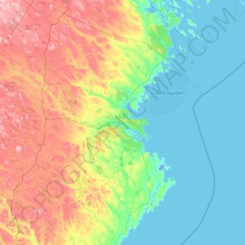
Name: Skellefteå kommun topographic map, elevation, terrain.
Location: Skellefteå kommun, Västerbotten County, Sweden (64.10766 19.34686 65.38096 22.08977)
Average elevation: 104 m
Minimum elevation: -6 m
Maximum elevation: 483 m
Thank you for supporting this site ❤️
Make a donation
Make a donation
Other topographic maps
Click on a map to view its topography, its elevation and its terrain.