
Thank you for supporting this site ❤️
Make a donation
Make a donation
Pütz topographic map
Click on the map to display elevation.
Thank you for supporting this site ❤️
Make a donation
Make a donation
About this map
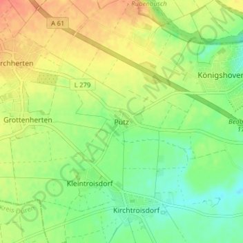
Name: Pütz topographic map, elevation, terrain.
Average elevation: 88 m
Minimum elevation: 67 m
Maximum elevation: 110 m
Thank you for supporting this site ❤️
Make a donation
Make a donation
Other topographic maps
Click on a map to view its topography, its elevation and its terrain.
50181
Deutschland > Nordrhein-Westfalen > Rhein-Erft-Kreis > Bedburg > Alt-Kaster
Average elevation: 75 m
Gewässer
Deutschland > Nordrhein-Westfalen > Rhein-Erft-Kreis > Bedburg > Epprath
Average elevation: 77 m