
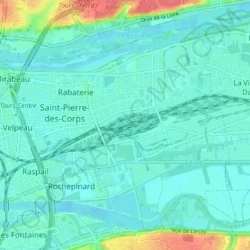
Saint-Pierre-des-Corps topographic map
Interactive map
Click on the map to display elevation.
About this map
Name: Saint-Pierre-des-Corps topographic map, elevation, terrain.
Average elevation: 55 m
Minimum elevation: 43 m
Maximum elevation: 104 m
Aucune partie du territoire communal situé entre Loire et Cher ne dépasse l'altitude de 50 m. Le point culminant de la commune (51 m) se trouve dans l'île des Buteaux sur la Loire.
Other topographic maps
Click on a map to view its topography, its elevation and its terrain.
Cheillé
France > Centre-Val de Loire > Indre-et-Loire
Cheillé, Tours, Indre-et-Loire, Centre-Val de Loire, France métropolitaine, 37190, France
Average elevation: 91 m
Descartes
France > Centre-Val de Loire > Indre-et-Loire
Descartes, Loches, Indre-et-Loire, Centre-Val de Loire, France métropolitaine, 37160, France
Average elevation: 90 m
Le Liège
France > Centre-Val de Loire > Indre-et-Loire
Le Liège, Loches, Indre-et-Loire, Centre-Val de Loire, France métropolitaine, 37460, France
Average elevation: 119 m
Tours
France > Centre-Val de Loire > Indre-et-Loire
Tours, Indre-et-Loire, Centre-Val de Loire, France métropolitaine, France
Average elevation: 73 m
Luzillé
France > Centre-Val de Loire > Indre-et-Loire
Luzillé, Loches, Indre-et-Loire, Centre-Val de Loire, France métropolitaine, 37150, France
Average elevation: 106 m
Draché
France > Centre-Val de Loire > Indre-et-Loire
Draché, Loches, Indre-et-Loire, Centre-Val de Loire, France métropolitaine, 37800, France
Average elevation: 85 m
La Ville
France > Centre-Val de Loire > Indre-et-Loire > Sainte-Maure-de-Touraine
La Ville, Sainte-Maure-de-Touraine, Chinon, Indre-et-Loire, Centre-Val de Loire, France métropolitaine, 37800, France
Average elevation: 97 m
Château
France > Centre-Val de Loire > Indre-et-Loire > Sainte-Maure-de-Touraine > La Ville
Château, Rue du Château, La Ville, Sainte-Maure-de-Touraine, Chinon, Indre-et-Loire, Centre-Val de Loire, France métropolitaine, 37800, France
Average elevation: 92 m
Les Évées
France > Centre-Val de Loire > Indre-et-Loire > Saint-Martin-le-Beau
Les Évées, Saint-Martin-le-Beau, Loches, Indre-et-Loire, Centre-Val de Loire, France métropolitaine, 37270, France
Average elevation: 71 m
Courçay
France > Centre-Val de Loire > Indre-et-Loire
Courçay, Loches, Indre-et-Loire, Centre-Val de Loire, France métropolitaine, 37310, France
Average elevation: 87 m
Monts
France > Centre-Val de Loire > Indre-et-Loire
Monts, Tours, Indre-et-Loire, Centre-Val de Loire, France métropolitaine, 37260, France
Average elevation: 81 m
Tours
France > Centre-Val de Loire > Indre-et-Loire > Tours
Tours, Indre-et-Loire, Centre-Val de Loire, France métropolitaine, 37000, France
Average elevation: 91 m
Marolle
France > Centre-Val de Loire > Indre-et-Loire > Genillé
Marolle, Genillé, Loches, Indre-et-Loire, Centre-Val de Loire, France métropolitaine, 37460, France
Average elevation: 122 m
Les Quarts
France > Centre-Val de Loire > Indre-et-Loire > Montbazon
Les Quarts, Montbazon, Arrondissement de Tours, Indre-et-Loire, Centre-Val de Loire, France métropolitaine, 37250, France
Average elevation: 78 m
Yzeures-sur-Creuse
France > Centre-Val de Loire > Indre-et-Loire
Yzeures-sur-Creuse, Loches, Indre-et-Loire, Centre-Val de Loire, France métropolitaine, 37290, France
Average elevation: 95 m
Tour Heurtault
France > Centre-Val de Loire > Indre-et-Loire > Amboise > La Ville-Sud
Tour Heurtault, Place Michel Debré, Quai du Maréchal Joffre, La Ville-Sud, Amboise, Loches, Indre-et-Loire, Centre-Val de Loire, France métropolitaine, 37400, France
Average elevation: 71 m
Cinais
France > Centre-Val de Loire > Indre-et-Loire > Cinais
Cinais, Chinon, Indre-et-Loire, Centre-Val de Loire, France métropolitaine, 37500, France
Average elevation: 49 m
Loches
France > Centre-Val de Loire > Indre-et-Loire
Loches, Indre-et-Loire, Centre-Val de Loire, France métropolitaine, 37600, France
Average elevation: 106 m
Richelieu
France > Centre-Val de Loire > Indre-et-Loire
Richelieu, Chinon, Indre-et-Loire, Centre-Val de Loire, France métropolitaine, 37120, France
Average elevation: 62 m
Langeais
France > Centre-Val de Loire > Indre-et-Loire > Langeais
Langeais, Chinon, Indre-et-Loire, Centre-Val de Loire, France métropolitaine, 37130, France
Average elevation: 82 m
Villaines-les-Rochers
France > Centre-Val de Loire > Indre-et-Loire
Villaines-les-Rochers, Arrondissement de Tours, Indre-et-Loire, Centre-Val de Loire, France métropolitaine, 37190, France
Average elevation: 97 m