
石塘镇 topographic map
Interactive map
Click on the map to display elevation.
About this map
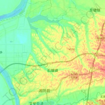
Name: 石塘镇 topographic map, elevation, terrain.
Location: 石塘镇, 湘阴县, 岳阳市, 湖南省, 中国 (28.67666 112.83561 28.78995 112.96225)
Average elevation: 41 m
Minimum elevation: 18 m
Maximum elevation: 76 m
Other topographic maps
Click on a map to view its topography, its elevation and its terrain.