
Thank you for supporting this site ❤️
Make a donation
Make a donation
Les Sapins topographic map
Click on the map to display elevation.
Thank you for supporting this site ❤️
Make a donation
Make a donation
About this map
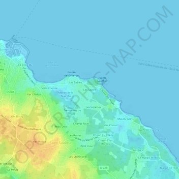
Name: Les Sapins topographic map, elevation, terrain.
Average elevation: 6 m
Minimum elevation: -1 m
Maximum elevation: 29 m
Thank you for supporting this site ❤️
Make a donation
Make a donation
Other topographic maps
Click on a map to view its topography, its elevation and its terrain.
85350
France > Pays de la Loire > Vendée > L'Île-d'Yeu > Saint-Sauveur > Ker Bossy
Average elevation: 18 m