
Courmayeur topographic map
Interactive map
Click on the map to display elevation.
About this map
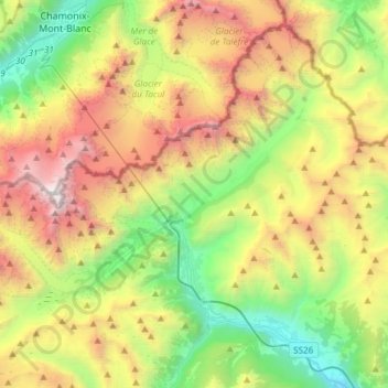
Name: Courmayeur topographic map, elevation, terrain.
Location: Courmayeur, Aosta Valley, 11013, Italy (45.74005 6.80153 45.92302 7.10155)
Average elevation: 2,366 m
Minimum elevation: 819 m
Maximum elevation: 4,800 m
At an elevation of 1,224 m (4,016 ft) above sea level, it is located at the foot of the southern side of Mont Blanc, at 4,810 m (15,781 ft) the highest point in the Alps and western Europe (see Seven Summits), and is crossed by the Dora Baltea (fr. Doire baltée) river.
Other topographic maps
Click on a map to view its topography, its elevation and its terrain.
Ghiacciaio del Miage
Italy > Aosta Valley > Courmayeur
Ghiacciaio del Miage, Sentiero 15 Rifugio Gonella, Courmayeur, Aosta Valley, Italy
Average elevation: 2,911 m
Mont Blanc - Monte Bianco
Italy > Aosta Valley > Courmayeur
Mont Blanc - Monte Bianco, Courmayeur, Aosta Valley, Italy
Average elevation: 4,092 m