
Thank you for supporting this site ❤️
Make a donation
Make a donation
Burgheßler topographic map
Click on the map to display elevation.
Thank you for supporting this site ❤️
Make a donation
Make a donation
Burgheßler
Burgheßler ist ein Kirchdorf mit ehemaligem Rittergut, acht Kilometer nordöstlich von Eckartsberga, im Tal des Haselbaches gelegen. Das Dorf liegt an der Kreisstraße 2236 zwischen Hohndorf und Klosterhäseler am Südrand eines Ausläufers der Finne (Höhenzug).
Thank you for supporting this site ❤️
Make a donation
Make a donation
About this map
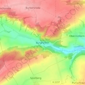
Name: Burgheßler topographic map, elevation, terrain.
Average elevation: 242 m
Minimum elevation: 172 m
Maximum elevation: 295 m
Thank you for supporting this site ❤️
Make a donation
Make a donation