
Thank you for supporting this site ❤️
Make a donation
Make a donation
Zscheiplitz topographic map
Click on the map to display elevation.
Thank you for supporting this site ❤️
Make a donation
Make a donation
About this map
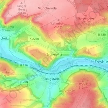
Name: Zscheiplitz topographic map, elevation, terrain.
Average elevation: 177 m
Minimum elevation: 104 m
Maximum elevation: 243 m
Thank you for supporting this site ❤️
Make a donation
Make a donation
Other topographic maps
Click on a map to view its topography, its elevation and its terrain.
Schweigenberge
Deutschland > Sachsen-Anhalt > Burgenlandkreis > Freyburg (Unstrut) > Zscheiplitz
Average elevation: 164 m