
Rio Grande do Sul topographic map
Interactive map
Click on the map to display elevation.
About this map
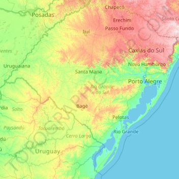
Name: Rio Grande do Sul topographic map, elevation, terrain.
Location: Rio Grande do Sul, South Region, Brazil (-33.86891 -57.64893 -27.08254 -49.53062)
Average elevation: 205 m
Minimum elevation: -3 m
Maximum elevation: 1,643 m
Other topographic maps
Click on a map to view its topography, its elevation and its terrain.