
Thank you for supporting this site ❤️
Make a donation
Make a donation
Long Nawang topographic map
Click on the map to display elevation.
Thank you for supporting this site ❤️
Make a donation
Make a donation
About this map
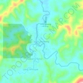
Name: Long Nawang topographic map, elevation, terrain.
Location: Long Nawang, North Kalimantan, Kalimantan, Indonesia (1.76935 114.88230 1.80935 114.92230)
Average elevation: 627 m
Minimum elevation: 574 m
Maximum elevation: 791 m
Thank you for supporting this site ❤️
Make a donation
Make a donation
Other topographic maps
Click on a map to view its topography, its elevation and its terrain.
Thank you for supporting this site ❤️
Make a donation
Make a donation
Malinau
Malinau borders Nunukan Regency in the north, Tana Tidung, Bulungan, and Berau regencies in the east, East Kutai, Kutai Kartanegara, and West Kutai regencies in the south, and the Malaysian state of Sabah in the west. From its 40,088.38 square kilometers of area, Kayan Mentarang National Park consist of 24.88%…
Average elevation: 627 m