
Thank you for supporting this site ❤️
Make a donation
Make a donation
Schlegel topographic map
Click on the map to display elevation.
Thank you for supporting this site ❤️
Make a donation
Make a donation
About this map
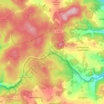
Name: Schlegel topographic map, elevation, terrain.
Average elevation: 637 m
Minimum elevation: 503 m
Maximum elevation: 736 m
Thank you for supporting this site ❤️
Make a donation
Make a donation
Other topographic maps
Click on a map to view its topography, its elevation and its terrain.
Blankenberg
Deutschland > Thüringen > Saale-Orla-Kreis > Rosenthal am Rennsteig > Blankenberg
Average elevation: 507 m