
Thank you for supporting this site ❤️
Make a donation
Make a donation
Bölkendorf topographic map
Click on the map to display elevation.
Thank you for supporting this site ❤️
Make a donation
Make a donation
About this map
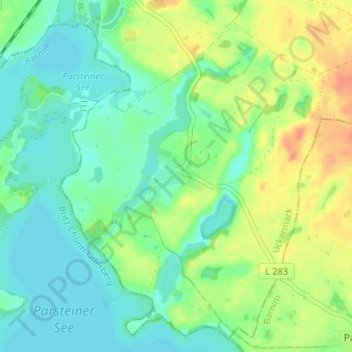
Name: Bölkendorf topographic map, elevation, terrain.
Location: Bölkendorf, Angermünde, Uckermark, Brandenburg, Deutschland (52.93000 13.98000 52.97000 14.02000)
Average elevation: 55 m
Minimum elevation: 40 m
Maximum elevation: 80 m
Thank you for supporting this site ❤️
Make a donation
Make a donation
Other topographic maps
Click on a map to view its topography, its elevation and its terrain.