
Thank you for supporting this site ❤️
Make a donation
Make a donation
Rawa Arum topographic map
Click on the map to display elevation.
Thank you for supporting this site ❤️
Make a donation
Make a donation
About this map
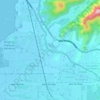
Name: Rawa Arum topographic map, elevation, terrain.
Location: Rawa Arum, Cilegon, Banten, Java, 42436, Indonesia (-6.00224 105.99025 -5.96224 106.03025)
Average elevation: 23 m
Minimum elevation: -8 m
Maximum elevation: 274 m
Thank you for supporting this site ❤️
Make a donation
Make a donation
Other topographic maps
Click on a map to view its topography, its elevation and its terrain.