
Thank you for supporting this site ❤️
Make a donation
Make a donation
Rotem topographic map
Click on the map to display elevation.
Thank you for supporting this site ❤️
Make a donation
Make a donation
About this map
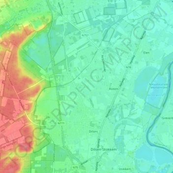
Name: Rotem topographic map, elevation, terrain.
Location: Rotem, Dilsen-Stokkem, Maaseik, Limburg, Vlaanderen, België (51.03631 5.66486 51.06964 5.77256)
Average elevation: 37 m
Minimum elevation: 23 m
Maximum elevation: 89 m
Thank you for supporting this site ❤️
Make a donation
Make a donation
Other topographic maps
Click on a map to view its topography, its elevation and its terrain.