
Thank you for supporting this site ❤️
Make a donation
Make a donation
Purwokerto Kulon topographic map
Click on the map to display elevation.
Thank you for supporting this site ❤️
Make a donation
Make a donation
About this map
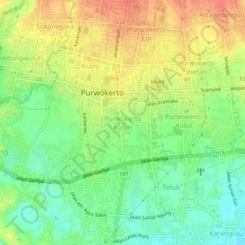
Name: Purwokerto Kulon topographic map, elevation, terrain.
Average elevation: 72 m
Minimum elevation: 47 m
Maximum elevation: 98 m
Thank you for supporting this site ❤️
Make a donation
Make a donation
Other topographic maps
Click on a map to view its topography, its elevation and its terrain.
Desa Banjar Anyar Kidul Kecamatan Sokaraja
Indonesia > Central Java > Banyumas
Average elevation: 43 m
Thank you for supporting this site ❤️
Make a donation
Make a donation