
Thank you for supporting this site ❤️
Make a donation
Make a donation
Satzvey topographic map
Click on the map to display elevation.
Thank you for supporting this site ❤️
Make a donation
Make a donation
Satzvey
Vom 11. August 1895 bis 31. Dezember 1965 führte durch Satzvey die sogenannte „Eifelstrecke“ der Euskirchener Kreisbahnen, die dort die Eifelbahn Köln – Trier höhengleich kreuzte. Ferner hat Satzvey einen eigenen Bahnhof an ebendieser Eifelbahn, der von RB-Zügen Köln – Kall bedient wird.
Thank you for supporting this site ❤️
Make a donation
Make a donation
About this map
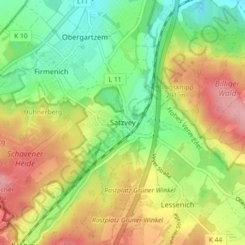
Name: Satzvey topographic map, elevation, terrain.
Average elevation: 248 m
Minimum elevation: 192 m
Maximum elevation: 317 m
Thank you for supporting this site ❤️
Make a donation
Make a donation
Other topographic maps
Click on a map to view its topography, its elevation and its terrain.
Angelteiche Feyermühle
Deutschland > Nordrhein-Westfalen > Kreis Euskirchen > Mechernich > Breitenbenden > Burgfey
Average elevation: 312 m
Bescheid
Deutschland > Nordrhein-Westfalen > Kreis Euskirchen > Mechernich > Bleibuir
Average elevation: 366 m