
Thank you for supporting this site ❤️
Make a donation
Make a donation
Carrabassett Valley topographic map
Click on the map to display elevation.
Thank you for supporting this site ❤️
Make a donation
Make a donation
About this map
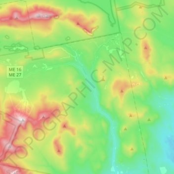
Name: Carrabassett Valley topographic map, elevation, terrain.
Average elevation: 495 m
Minimum elevation: 137 m
Maximum elevation: 1,280 m
Thank you for supporting this site ❤️
Make a donation
Make a donation
Other topographic maps
Click on a map to view its topography, its elevation and its terrain.
Thank you for supporting this site ❤️
Make a donation
Make a donation
Sandy River Plantation
United States > Maine > Franklin County > Sandy River Plantation
Average elevation: 589 m
Height of Land Scenic Overlook
United States > Maine > Franklin County > Township D > Rangeley Plantation
Average elevation: 601 m
Thank you for supporting this site ❤️
Make a donation
Make a donation