
Make a donation
Cortazar topographic map
Click on the map to display elevation.
Make a donation
About this map
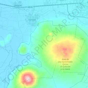
Name: Cortazar topographic map, elevation, terrain.
Location: Cortazar, Guanajuato, Mexico (20.32836 -101.04741 20.51563 -100.82361)
Average elevation: 1,889 m
Minimum elevation: 1,724 m
Maximum elevation: 2,840 m
Make a donation
Other topographic maps
Click on a map to view its topography, its elevation and its terrain.
Make a donation
San Francisco del Rincón
Mexico > Guanajuato > San Francisco del Rincón
The settlement was founded as San Francisco del Tule on January 21, 1607 by a group of families of the Purépecha and Hñähñu (Otomi) ethnicities. It was declared a villa (town) on September 6, 1865 and a city on March 27, 1867. It is located at 21°01′22″N 101°51′36″W / 21.02278°N…
Average elevation: 1,767 m
Make a donation
San Miguel de Allende
Mexico > Guanajuato > San Miguel de Allende > San Miguel de Allende
Average elevation: 2,029 m
Dolores Hidalgo
Mexico > Guanajuato > Dolores Hidalgo
It is located at 21°10′N 100°56′W / 21.17°N 100.93°W / 21.17; -100.93, at an elevation of about 1,980 meters (6,480 feet) above sea level. In the census of 2005 the city had a population of 54,843, while the municipality had 134,641 inhabitants. The city lies directly in the center of the…
Average elevation: 1,938 m
Make a donation