
Thank you for supporting this site ❤️
Make a donation
Make a donation
Kamp topographic map
Click on the map to display elevation.
Thank you for supporting this site ❤️
Make a donation
Make a donation
About this map
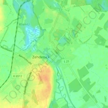
Name: Kamp topographic map, elevation, terrain.
Location: Kamp, Zehdenick, Oberhavel, Brandenburg, 16792, Deutschland (52.96057 13.32294 53.00057 13.36294)
Average elevation: 48 m
Minimum elevation: 36 m
Maximum elevation: 64 m
Thank you for supporting this site ❤️
Make a donation
Make a donation
Other topographic maps
Click on a map to view its topography, its elevation and its terrain.