Geolocate

Woodgate topographic map

Click on the map to display elevation.

About this map

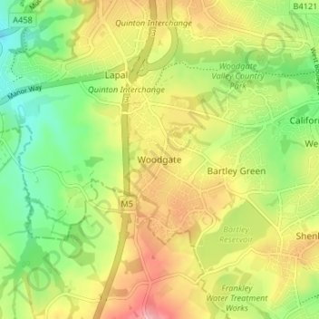
Name: Woodgate topographic map, elevation, terrain.

Location: Woodgate, Birmingham, West Midlands, England, B32 4LR, United Kingdom (52.41735 -2.03076 52.45735 -1.99076)

Average elevation: 176 m

Minimum elevation: 114 m

Maximum elevation: 248 m

Other topographic maps

Click on a map to view its topography, its elevation and its terrain.

Sutton Coldfield

United Kingdom > England > Birmingham

Average elevation: 124 m

Sutton Park

United Kingdom > England > Birmingham > Four Oaks

Average elevation: 145 m

Sutton Coldfield

United Kingdom > England > Birmingham

Average elevation: 124 m

Joy's Wood

United Kingdom > England > Birmingham > Wake Green

Average elevation: 140 m

Lifford Reservoir

United Kingdom > England > Birmingham > Lifford

Average elevation: 150 m

North Edgbaston

United Kingdom > England > Birmingham

Average elevation: 162 m

Sutton Park

United Kingdom > England > Birmingham > Four Oaks

Average elevation: 145 m

Pype Hayes

United Kingdom > England > Birmingham > Tyburn

Average elevation: 104 m

Highbury Park

United Kingdom > England > Birmingham > Kings Heath

Average elevation: 142 m

Sutton Coldfield

United Kingdom > England > Birmingham

Average elevation: 124 m