
Thank you for supporting this site ❤️
Make a donation
Make a donation
La Caserne topographic map
Click on the map to display elevation.
Thank you for supporting this site ❤️
Make a donation
Make a donation
About this map
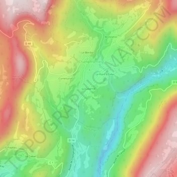
Name: La Caserne topographic map, elevation, terrain.
Average elevation: 792 m
Minimum elevation: 469 m
Maximum elevation: 1,172 m
Thank you for supporting this site ❤️
Make a donation
Make a donation
Other topographic maps
Click on a map to view its topography, its elevation and its terrain.
Mégaphorbiaie Combe d'Evuaz
France > Auvergne-Rhône-Alpes > Ain > Champfromier
Average elevation: 1,197 m