
Thank you for supporting this site ❤️
Make a donation
Make a donation
Wawern topographic map
Click on the map to display elevation.
Thank you for supporting this site ❤️
Make a donation
Make a donation
About this map
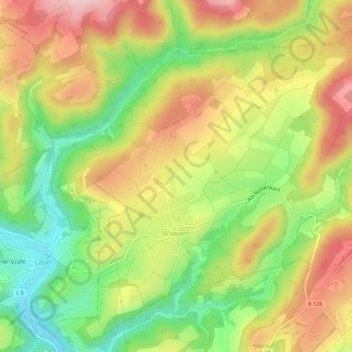
Name: Wawern topographic map, elevation, terrain.
Location: Wawern, Prüm, Eifelkreis Bitburg-Prüm, Rijnland-Palts, Duitsland (50.10554 6.46905 50.13674 6.52330)
Average elevation: 448 m
Minimum elevation: 344 m
Maximum elevation: 552 m
Thank you for supporting this site ❤️
Make a donation
Make a donation
Other topographic maps
Click on a map to view its topography, its elevation and its terrain.
Stalbach
Duitsland > Rijnland-Palts > Eifelkreis Bitburg-Prüm > Lichtenborn > Stalbach
Average elevation: 498 m
Thank you for supporting this site ❤️
Make a donation
Make a donation