
Thank you for supporting this site ❤️
Make a donation
Make a donation
Phimai topographic map
Click on the map to display elevation.
Thank you for supporting this site ❤️
Make a donation
Make a donation
About this map
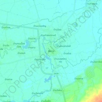
Name: Phimai topographic map, elevation, terrain.
Average elevation: 155 m
Minimum elevation: 149 m
Maximum elevation: 190 m
Thank you for supporting this site ❤️
Make a donation
Make a donation
Other topographic maps
Click on a map to view its topography, its elevation and its terrain.
Lam Takhong Reservoir
Thailand > Nakhon Ratchasima Province > Ban Khlong Phai
Average elevation: 371 m