
Thank you for supporting this site ❤️
Make a donation
Make a donation
Spreewald topographic map
Click on the map to display elevation.
Thank you for supporting this site ❤️
Make a donation
Make a donation
About this map
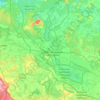
Name: Spreewald topographic map, elevation, terrain.
Location: Spreewald, Dahme-Spreewald, Brandenburg, Duitsland (51.76884 13.77273 52.13778 14.25765)
Average elevation: 57 m
Minimum elevation: 32 m
Maximum elevation: 152 m
Thank you for supporting this site ❤️
Make a donation
Make a donation
Other topographic maps
Click on a map to view its topography, its elevation and its terrain.
Kessel
Duitsland > Brandenburg > Dahme-Spreewald > Märkische Heide > Alt Schadow
Average elevation: 50 m