
Thank you for supporting this site ❤️
Make a donation
Make a donation
Hohenhausen topographic map
Click on the map to display elevation.
Thank you for supporting this site ❤️
Make a donation
Make a donation
Hohenhausen
Der Ort liegt im Bundesland Nordrhein-Westfalen im Kreis Lippe. Er liegt 10 Kilometer nördlich von Lemgo, 20 Kilometer nördlich von Detmold, 28 km nordöstlich von Bielefeld, 21 km südlich von Minden und 14 km südwestlich von Rinteln. Hohenhausen liegt im Tal des Baches Westerkalle auf einer Höhe von etwa 160 Metern über NN.
Thank you for supporting this site ❤️
Make a donation
Make a donation
About this map
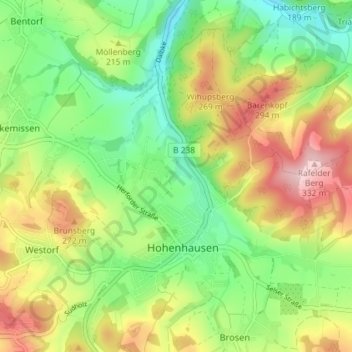
Name: Hohenhausen topographic map, elevation, terrain.
Average elevation: 201 m
Minimum elevation: 105 m
Maximum elevation: 336 m
Thank you for supporting this site ❤️
Make a donation
Make a donation
Other topographic maps
Click on a map to view its topography, its elevation and its terrain.
Vogelhorst
Deutschland > Nordrhein-Westfalen > Kreis Lippe > Lemgo > Voßheide
Average elevation: 143 m
Thank you for supporting this site ❤️
Make a donation
Make a donation