
Thank you for supporting this site ❤️
Make a donation
Make a donation
Kirchhain topographic map
Click on the map to display elevation.
Thank you for supporting this site ❤️
Make a donation
Make a donation
About this map
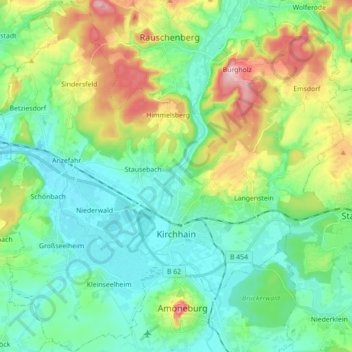
Name: Kirchhain topographic map, elevation, terrain.
Location: Kirchhain, Landkreis Marburg-Biedenkopf, Hesse, 35274, Germany (50.78381 8.82814 50.89459 9.00436)
Average elevation: 244 m
Minimum elevation: 189 m
Maximum elevation: 381 m
Thank you for supporting this site ❤️
Make a donation
Make a donation
Other topographic maps
Click on a map to view its topography, its elevation and its terrain.
Aurorahütte
Germany > Hesse > Landkreis Marburg-Biedenkopf > Gladenbach > Erdhausen
Average elevation: 298 m