
Town of Paris topographic map
Interactive map
Click on the map to display elevation.
About this map
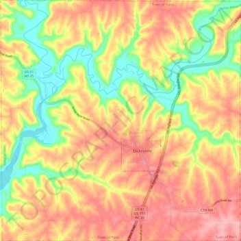
Name: Town of Paris topographic map, elevation, terrain.
Location: Town of Paris, Grant County, Wisconsin, United States (42.59441 -90.66238 42.68214 -90.54321)
Average elevation: 252 m
Minimum elevation: 180 m
Maximum elevation: 310 m
Other topographic maps
Click on a map to view its topography, its elevation and its terrain.
Montfort
United States > Wisconsin > Grant County
Montfort, Grant County, Wisconsin, United States
Average elevation: 348 m
Hazel Green
United States > Wisconsin > Grant County
Hazel Green, Grant County, Wisconsin, United States
Average elevation: 278 m
Bloomington
United States > Wisconsin > Grant County
Bloomington, Grant County, Wisconsin, United States
Average elevation: 300 m
Bagley
United States > Wisconsin > Grant County
Bagley, Grant County, Wisconsin, United States
Average elevation: 207 m
Mount Hope
United States > Wisconsin > Grant County
Mount Hope, Grant County, Wisconsin, United States
Average elevation: 349 m
Village of Woodman
United States > Wisconsin > Grant County
Village of Woodman, Grant County, Wisconsin, United States
Average elevation: 236 m
Town of Glen Haven
United States > Wisconsin > Grant County
Town of Glen Haven, Grant County, Wisconsin, 53810, United States
Average elevation: 262 m
Kieler
United States > Wisconsin > Grant County
Kieler, Town of Jamestown, Grant County, Wisconsin, 53812, United States
Average elevation: 275 m
Cuba City
United States > Wisconsin > Grant County
Cuba City, Grant County, Wisconsin, United States
Average elevation: 301 m
Potosi
United States > Wisconsin > Grant County
Potosi, Grant County, Wisconsin, United States
Average elevation: 264 m
Patch Grove
United States > Wisconsin > Grant County
Patch Grove, Grant County, Wisconsin, United States
Average elevation: 336 m
Tennyson
United States > Wisconsin > Grant County
Tennyson, Grant County, Wisconsin, United States
Average elevation: 282 m
Sandy Hook
United States > Wisconsin > Grant County
Sandy Hook, Town of Jamestown, Grant County, Wisconsin, 53812, United States
Average elevation: 245 m
Town of Beetown
United States > Wisconsin > Grant County
Town of Beetown, Grant County, Wisconsin, 53802, United States
Average elevation: 281 m
Sinsinawa
United States > Wisconsin > Grant County
Sinsinawa, Town of Hazel Green, Grant County, Wisconsin, United States
Average elevation: 277 m
Stitzer
United States > Wisconsin > Grant County
Stitzer, Town of Liberty, Grant County, Wisconsin, 53825, United States
Average elevation: 331 m
Van Buren
United States > Wisconsin > Grant County > Potosi
Van Buren, Potosi, Grant County, Wisconsin, 53820, United States
Average elevation: 242 m
Fennimore
United States > Wisconsin > Grant County
Fennimore, Grant County, Wisconsin, United States
Average elevation: 353 m
Mississippi River
United States > Wisconsin > Grant County > Dubuque
Mississippi River, Dubuque, Town of Jamestown, Grant County, Wisconsin, 52001, United States
Average elevation: 203 m
Platteville
United States > Wisconsin > Grant County
Platteville, Grant County, Wisconsin, 53818, United States
Average elevation: 295 m
Dickeyville
United States > Wisconsin > Grant County
Dickeyville, Grant County, Wisconsin, 53808, United States
Average elevation: 275 m
Lancaster
United States > Wisconsin > Grant County
Lancaster, Grant County, Wisconsin, 53813, United States
Average elevation: 326 m
Livingston
United States > Wisconsin > Grant County
Livingston, Grant County, Wisconsin, United States
Average elevation: 345 m
Town of Wyalusing
United States > Wisconsin > Grant County
Town of Wyalusing, Grant County, Wisconsin, 53801, United States
Average elevation: 264 m
Blue River
United States > Wisconsin > Grant County
Blue River, Grant County, Wisconsin, United States
Average elevation: 223 m
Boscobel
United States > Wisconsin > Grant County
Boscobel, Grant County, Wisconsin, United States
Average elevation: 223 m
Cassville
United States > Wisconsin > Grant County
Cassville, Grant County, Wisconsin, United States
Average elevation: 222 m
Muscoda
United States > Wisconsin > Grant County
Muscoda, Grant County, Wisconsin, United States
Average elevation: 210 m