
Thank you for supporting this site ❤️
Make a donation
Make a donation
Goulais Mission topographic map
Click on the map to display elevation.
Thank you for supporting this site ❤️
Make a donation
Make a donation
About this map
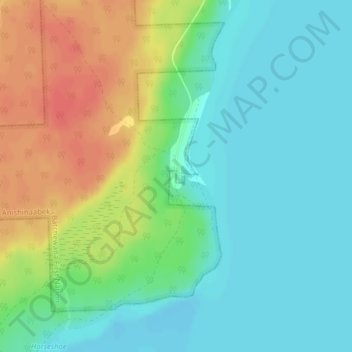
Name: Goulais Mission topographic map, elevation, terrain.
Average elevation: 196 m
Minimum elevation: 177 m
Maximum elevation: 228 m
Thank you for supporting this site ❤️
Make a donation
Make a donation
Other topographic maps
Click on a map to view its topography, its elevation and its terrain.
Granitehill Lake
Canada > Ontario > Algoma District > Unorganized North Algoma
Average elevation: 380 m
Lauzon Lake
Canada > Ontario > Algoma District > The North Shore Township > Algoma Mills
Average elevation: 210 m
Thank you for supporting this site ❤️
Make a donation
Make a donation
Thank you for supporting this site ❤️
Make a donation
Make a donation
Obakamiga River;Redfin Lake
Canada > Ontario > Algoma District > Unorganized North Algoma
Average elevation: 343 m