
Thank you for supporting this site ❤️
Make a donation
Make a donation
Oberes Schloss topographic map
Click on the map to display elevation.
Thank you for supporting this site ❤️
Make a donation
Make a donation
About this map
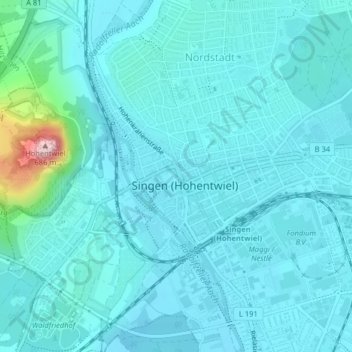
Name: Oberes Schloss topographic map, elevation, terrain.
Average elevation: 449 m
Minimum elevation: 420 m
Maximum elevation: 682 m
Thank you for supporting this site ❤️
Make a donation
Make a donation
Other topographic maps
Click on a map to view its topography, its elevation and its terrain.
78224
Deutschland > Baden-Württemberg > Landkreis Konstanz > Singen (Hohentwiel)
Average elevation: 462 m
Beuren an der Aach
Deutschland > Baden-Württemberg > Landkreis Konstanz > Singen (Hohentwiel)
Beuren liegt auf einer Höhe von 439 m ü. NHN, am Umspannwerk Beuren und am Autobahnkreuz Hegau, das sich komplett auf Gemarkung des Ortes befindet.
Average elevation: 448 m