
Thank you for supporting this site ❤️
Make a donation
Make a donation
Kumtich topographic map
Click on the map to display elevation.
Thank you for supporting this site ❤️
Make a donation
Make a donation
Kumtich
Kumtich ligt in de Haspengouw op een hoogte van 58-100 meter. Het hoogste punt is de Kapuin.
Thank you for supporting this site ❤️
Make a donation
Make a donation
About this map
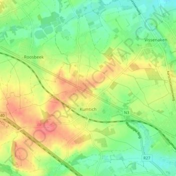
Name: Kumtich topographic map, elevation, terrain.
Location: Kumtich, Tienen, Leuven, Vlaams-Brabant, Vlaanderen, België (50.80034 4.85172 50.84890 4.91405)
Average elevation: 64 m
Minimum elevation: 36 m
Maximum elevation: 99 m
Thank you for supporting this site ❤️
Make a donation
Make a donation
Other topographic maps
Click on a map to view its topography, its elevation and its terrain.