
Thank you for supporting this site ❤️
Make a donation
Make a donation
Brighton topographic map
Click on the map to display elevation.
Thank you for supporting this site ❤️
Make a donation
Make a donation
About this map
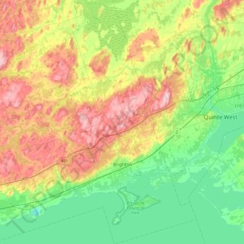
Name: Brighton topographic map, elevation, terrain.
Average elevation: 129 m
Minimum elevation: 48 m
Maximum elevation: 262 m
Thank you for supporting this site ❤️
Make a donation
Make a donation
Other topographic maps
Click on a map to view its topography, its elevation and its terrain.
Grafton
Canada > Ontario > Northumberland County > Alnwick/Haldimand > Grafton
Average elevation: 124 m
Presqu'ile Provincial Park
Canada > Ontario > Northumberland County > Brighton
Average elevation: 76 m
Thank you for supporting this site ❤️
Make a donation
Make a donation
Camborne
Canada > Ontario > Northumberland County > Hamilton Township > Camborne
Average elevation: 196 m
Campbellford
Canada > Ontario > Northumberland County > Trent Hills > Campbellford
Average elevation: 174 m
Thank you for supporting this site ❤️
Make a donation
Make a donation