
Thank you for supporting this site ❤️
Make a donation
Make a donation
Egem topographic map
Click on the map to display elevation.
Thank you for supporting this site ❤️
Make a donation
Make a donation
About this map
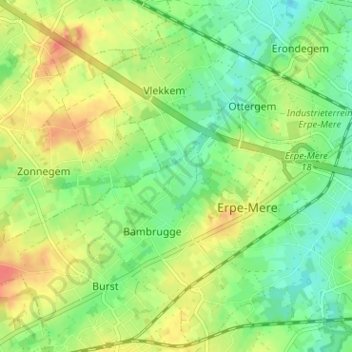
Name: Egem topographic map, elevation, terrain.
Location: Egem, Bambrugge, Erpe-Mere, Aalst, Oost-Vlaanderen, 9420, België (50.90615 3.91311 50.94615 3.95311)
Average elevation: 39 m
Minimum elevation: 17 m
Maximum elevation: 65 m
Thank you for supporting this site ❤️
Make a donation
Make a donation
Other topographic maps
Click on a map to view its topography, its elevation and its terrain.