
Make a donation
Saddle Mountain topographic map
Click on the map to display elevation.
Make a donation
Saddle Mountain
The hike to the taller of the two peaks is a 6-mile (9.7 km) round trip consisting of challenging terrain. Elevation gain is 1,603 feet (489 m) and leads to a 360-degree view to the Pacific Ocean, Cascade Mountain peaks such as Mount Hood, Mount St. Helens, Mount Rainier, Mount Adams, and other peaks in the Coast Range. The lower peak—elevation 3,200 feet (980 m)— to the east and south does not have trail access. The trail is steep at times along rock outcroppings, but does offer views that include wildflowers in bloom in the springtime. Beside the trailhead is a picnic area and a primitive walk-in campground.
Make a donation
About this map
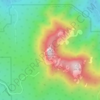
Name: Saddle Mountain topographic map, elevation, terrain.
Location: Saddle Mountain, Clatsop County, Oregon, United States (45.96902 -123.68542 45.96912 -123.68532)
Average elevation: 527 m
Minimum elevation: 252 m
Maximum elevation: 974 m
Make a donation
Other topographic maps
Click on a map to view its topography, its elevation and its terrain.
Cannon Beach
United States > Oregon > Clatsop County
Cannon Beach is recognized by the well-known landmark Haystack Rock, located southwest of downtown Cannon Beach. This sea stack has an elevation of 235 feet (72 m) and is often accessible at low tide, especially in the summertime. There is a small cave system that penetrates its igneous rock that can be seen…
Average elevation: 42 m
Make a donation