
Thank you for supporting this site ❤️
Make a donation
Make a donation
Hampden topographic map
Click on the map to display elevation.
Thank you for supporting this site ❤️
Make a donation
Make a donation
About this map
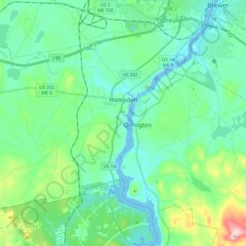
Name: Hampden topographic map, elevation, terrain.
Location: Hampden, Penobscot County, Maine, 04444, United States (44.68068 -68.96519 44.78339 -68.78128)
Average elevation: 53 m
Minimum elevation: -6 m
Maximum elevation: 254 m
Thank you for supporting this site ❤️
Make a donation
Make a donation
Other topographic maps
Click on a map to view its topography, its elevation and its terrain.
Thank you for supporting this site ❤️
Make a donation
Make a donation
Thank you for supporting this site ❤️
Make a donation
Make a donation