
Thank you for supporting this site ❤️
Make a donation
Make a donation
La Calera topographic map
Click on the map to display elevation.
Thank you for supporting this site ❤️
Make a donation
Make a donation
About this map
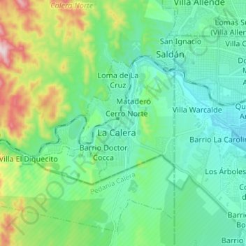
Name: La Calera topographic map, elevation, terrain.
Average elevation: 555 m
Minimum elevation: 429 m
Maximum elevation: 964 m
Thank you for supporting this site ❤️
Make a donation
Make a donation
Other topographic maps
Click on a map to view its topography, its elevation and its terrain.
Cordoba
Argentina > Córdoba > Pedanía Capital
The wealthier suburbs west of the city are located at slightly higher altitudes, which allows cool breezes to blow in the summer, bringing drier, comfortable nights during hotter periods, and more regular frost in the winter. Generally speaking, Córdoba's daytime temperatures are very slightly warmer than…
Average elevation: 457 m
Observatorio Las Punillas
Argentina > Córdoba > Pedanía Alta Gracia > Alta Gracia
Average elevation: 566 m
Thank you for supporting this site ❤️
Make a donation
Make a donation
Thank you for supporting this site ❤️
Make a donation
Make a donation
Thank you for supporting this site ❤️
Make a donation
Make a donation
Thank you for supporting this site ❤️
Make a donation
Make a donation