
Thank you for supporting this site ❤️
Make a donation
Make a donation
Little River topographic map
Click on the map to display elevation.
Thank you for supporting this site ❤️
Make a donation
Make a donation
About this map
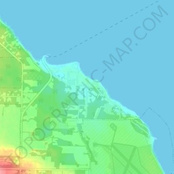
Name: Little River topographic map, elevation, terrain.
Average elevation: 13 m
Minimum elevation: 0 m
Maximum elevation: 77 m
Thank you for supporting this site ❤️
Make a donation
Make a donation
Other topographic maps
Click on a map to view its topography, its elevation and its terrain.
Kitty Coleman Beach Provincial Park
Canada > British Columbia > Comox Valley Regional District > Area B (Lazo North)
Average elevation: 18 m