
Make a donation
Villa Verde topographic map
Click on the map to display elevation.
Make a donation
About this map
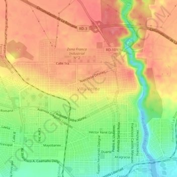
Name: Villa Verde topographic map, elevation, terrain.
Location: Villa Verde, La Romana, Dominican Republic (18.41657 -68.99570 18.45657 -68.95570)
Average elevation: 45 m
Minimum elevation: -8 m
Maximum elevation: 78 m
Make a donation
Other topographic maps
Click on a map to view its topography, its elevation and its terrain.
Catalina Island
Dominican Republic > La Romana > La Romana > Caleta
The island itself is only 9.6 square kilometers in size, and is a diverse preservation of eco-systems including sand dunes, mangroves, and reefs. Formed out of coral stone, the island contains three overlapping plateaus. The highest elevation on the island is only 60 feet above sea level. The seas around the…
Average elevation: 2 m