
La Sagne topographic map
Interactive map
Click on the map to display elevation.
About this map
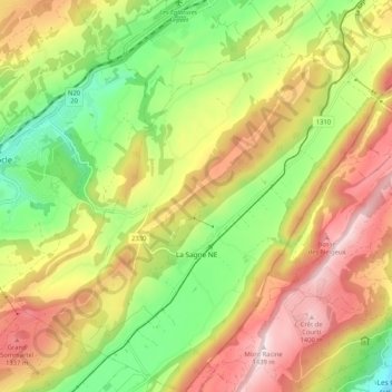
Name: La Sagne topographic map, elevation, terrain.
Location: La Sagne, Neuenburg, 2314, Schweiz (47.01371 6.75098 47.08433 6.84621)
Average elevation: 1,132 m
Minimum elevation: 861 m
Maximum elevation: 1,432 m
La Sagne liegt auf 1039 m ü. M., 6 km südsüdwestlich der Bezirkshauptstadt La Chaux-de-Fonds (Luftlinie). Das rund 2,5 km lange Strassenzeilendorf erstreckt sich im Nordosten des Hochtals Vallée des Ponts im Neuenburger Jura, westlich der Höhen von Tête de Ran und Mont Racine.
Other topographic maps
Click on a map to view its topography, its elevation and its terrain.
Grotte de la Cascade
Schweiz > Neuenburg > Val-de-Travers > Môtiers
Grotte de la Cascade, Grande Rue, Môtiers, Val-de-Travers, Neuenburg, 2112, Schweiz
Average elevation: 885 m