
Thank you for supporting this site ❤️
Make a donation
Make a donation
Mount Herbert topographic map
Click on the map to display elevation.
Thank you for supporting this site ❤️
Make a donation
Make a donation
About this map
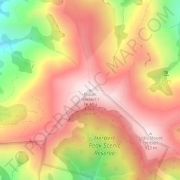
Name: Mount Herbert topographic map, elevation, terrain.
Average elevation: 661 m
Minimum elevation: 254 m
Maximum elevation: 918 m
Thank you for supporting this site ❤️
Make a donation
Make a donation
Other topographic maps
Click on a map to view its topography, its elevation and its terrain.
Waipuna Saddle Scenic Reserve
New Zealand > Christchurch City > Banks Peninsula Community
Average elevation: 519 m