
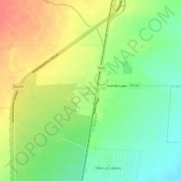
Estación Juárez Celman topographic map
Interactive map
Click on the map to display elevation.
About this map
Name: Estación Juárez Celman topographic map, elevation, terrain.
Average elevation: 497 m
Minimum elevation: 470 m
Maximum elevation: 526 m
Other topographic maps
Click on a map to view its topography, its elevation and its terrain.
Unquillo
Argentina > Córdova > Pedanía Río Ceballos
Unquillo, Pedanía Río Ceballos, Departamento Colón, Córdova, X5111, Argentina
Average elevation: 634 m
Río Ceballos
Argentina > Córdova > Pedanía Río Ceballos
Río Ceballos, Municipio de Río Ceballos, Pedanía Río Ceballos, Departamento Colón, Córdova, X5111, Argentina
Average elevation: 755 m