
Thank you for supporting this site ❤️
Make a donation
Make a donation
Ward Butte topographic map
Click on the map to display elevation.
Thank you for supporting this site ❤️
Make a donation
Make a donation
About this map
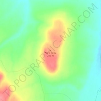
Name: Ward Butte topographic map, elevation, terrain.
Location: Ward Butte, Umatilla County, Oregon, 97826, United States (45.73092 -119.38812 45.73102 -119.38802)
Average elevation: 239 m
Minimum elevation: 207 m
Maximum elevation: 288 m
Thank you for supporting this site ❤️
Make a donation
Make a donation
Other topographic maps
Click on a map to view its topography, its elevation and its terrain.