Geolocate

Etinan topographic map

Interactive map

Click on the map to display elevation.

About this map

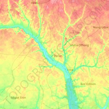
Name: Etinan topographic map, elevation, terrain.

Location: Etinan, Akwa Ibom, Nigeria (4.70316 7.80049 4.98774 7.88703)

Average elevation: 37 m

Minimum elevation: 2 m

Maximum elevation: 69 m

Other topographic maps

Click on a map to view its topography, its elevation and its terrain.

Etim Ekpo

Nigeria > Akwa Ibom > Etim Ekpo

Average elevation: 47 m

Okobo Ebughu

Nigeria > Akwa Ibom > Okobo Ebughu

Average elevation: 11 m

Kwa Ibo River

Nigeria > Akwa Ibom

Average elevation: 4 m

Ikot Ekpene

Nigeria > Akwa Ibom > Ikot Ekpene

Average elevation: 76 m

Uyo

Nigeria > Akwa Ibom > Uyo

Average elevation: 49 m

Ikot-Offiong

Nigeria > Akwa Ibom > Ikot-Offiong

Average elevation: 16 m

Nung Udoe

Nigeria > Akwa Ibom > Nung Udoe

Average elevation: 49 m