
Thank you for supporting this site ❤️
Make a donation
Make a donation
Upper Fraser topographic map
Click on the map to display elevation.
Thank you for supporting this site ❤️
Make a donation
Make a donation
About this map
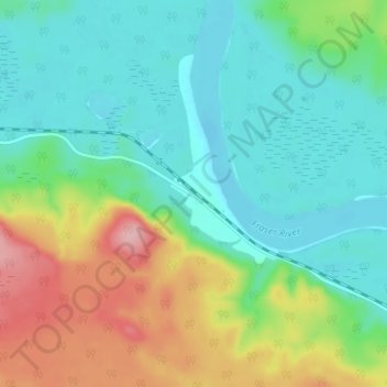
Name: Upper Fraser topographic map, elevation, terrain.
Average elevation: 647 m
Minimum elevation: 601 m
Maximum elevation: 751 m
Thank you for supporting this site ❤️
Make a donation
Make a donation
Other topographic maps
Click on a map to view its topography, its elevation and its terrain.
Purden Lake
Canada > British Columbia > Regional District of Fraser-Fort George > Area F (Willow River/Upper Fraser)
Average elevation: 922 m