
Thank you for supporting this site ❤️
Make a donation
Make a donation
Betzenrod topographic map
Click on the map to display elevation.
Thank you for supporting this site ❤️
Make a donation
Make a donation
About this map
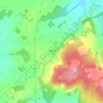
Name: Betzenrod topographic map, elevation, terrain.
Location: Betzenrod, Eiterfeld, Landkreis Fulda, Hessen, Deutschland (50.72442 9.75955 50.74121 9.78393)
Average elevation: 364 m
Minimum elevation: 311 m
Maximum elevation: 435 m
Thank you for supporting this site ❤️
Make a donation
Make a donation
Other topographic maps
Click on a map to view its topography, its elevation and its terrain.