
Réunion topographic map
Interactive map
Click on the map to display elevation.
Réunion
Already at the time of the India Route or Route des Indes, Réunion was a French possession located between Cape Town and the Indian trading posts, although far from the Mozambique Channel. Île de Bourbon (its name under the Ancien Régime) was not, however, the preferred position for trade and military. Governor Labourdonnais claimed that Île de France (Mauritius) was a land of opportunity, thanks to its topography and the presence of two natural harbours. He intended Île de Bourbon to be a depot or an emergency base for Île de France.
About this map
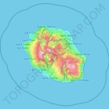
Name: Réunion topographic map, elevation, terrain.
Location: Réunion, France (-21.59045 55.00328 -20.67276 56.05079)
Average elevation: 186 m
Minimum elevation: 0 m
Maximum elevation: 3,014 m
Other topographic maps
Click on a map to view its topography, its elevation and its terrain.
Col du Galibier
France > Provence-Alpes-Côte d'Azur > Hautes-Alpes > Le Monêtier-les-Bains
Before 1976, the tunnel was the only point of passage at the top, at an altitude of 2556 m. The tunnel was closed for restoration until 2002, and a new road was constructed over the summit. The re-opened tunnel is a single lane controlled by traffic lights, which are among the highest such installations in…
Average elevation: 2,491 m
La Bachellerie-du-Nord
France > Nouvelle-Aquitaine > Haute-Vienne > Saint-Yrieix-la-Perche
Average elevation: 386 m
Plan d'eau privé
France > Pays de la Loire > Loire-Atlantique > Prinquiau > Clas
Average elevation: 54 m
Pyrenees
The Pyrenees (/ˈpɪrɪniːz/; Spanish: Pirineos [piɾiˈneos]; French: Pyrénées [piʁene] (listen); Catalan: Pirineu [piɾiˈnɛw]; Basque: Pirinioak [piɾini.o.ak]; Occitan: Pirenèus [piɾeˈnɛws]; Aragonese: Pirineus) is a mountain range straddling the border of France and Spain. It extends nearly 500…
Average elevation: 484 m
Le Planet
France > Auvergne-Rhône-Alpes > Upper Savoy > Chamonix-Mont-Blanc > Le Planet
Average elevation: 1,672 m
Les Chaussendents
France > Provence-Alpes-Côte d'Azur > Hautes-Alpes > La Chapelle-en-Valgaudémar > Les Chaussendents
Average elevation: 1,619 m
Eget Village
France > Occitania > Hautes Pyrenees > Aragnouet > Eget Village
Average elevation: 1,560 m