
Göttingerode topographic map
Interactive map
Click on the map to display elevation.
About this map
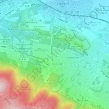
Name: Göttingerode topographic map, elevation, terrain.
Average elevation: 288 m
Minimum elevation: 201 m
Maximum elevation: 526 m
Other topographic maps
Click on a map to view its topography, its elevation and its terrain.
Ettersberg
Deutschland > Niedersachsen > Landkreis Goslar > Bad Harzburg
Ettersberg, Bad Harzburg, Landkreis Goslar, Niedersachsen, 38667, Deutschland
Average elevation: 474 m
Harlingerode
Deutschland > Niedersachsen > Landkreis Goslar > Bad Harzburg
Harlingerode, Bad Harzburg, Landkreis Goslar, Niedersachsen, Deutschland
Average elevation: 199 m
Schlewecke
Deutschland > Niedersachsen > Landkreis Goslar > Bad Harzburg
Schlewecke, Bad Harzburg, Landkreis Goslar, Niedersachsen, Deutschland
Average elevation: 239 m
Bündheim
Deutschland > Niedersachsen > Landkreis Goslar > Bad Harzburg
Bündheim, Bad Harzburg, Landkreis Goslar, Niedersachsen, 38667, Deutschland
Average elevation: 310 m