
Make a donation
Ajacuba topographic map
Click on the map to display elevation.
Make a donation
Ajacuba
It is located between the parallels 99° 27’ 51” and 99° 07’ 32” west longitude, and 20° 05’ 35” and 18° 55’ 22” north latitude. Ajacuba borders. It covers a total surface area of 192.7 km² at an altitude of 6,634 ft. In the year 2010 census by INEGI, it reported a population of 17,055.
Make a donation
About this map
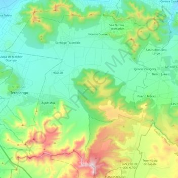
Name: Ajacuba topographic map, elevation, terrain.
Location: Ajacuba, Hidalgo, 42156, Mexico (20.01792 -99.18900 20.19528 -98.96783)
Average elevation: 2,280 m
Minimum elevation: 2,005 m
Maximum elevation: 2,998 m
Make a donation
Other topographic maps
Click on a map to view its topography, its elevation and its terrain.
Pachuca
Mexico > Hidalgo > Pachuca de Soto
Pachuca has a semi-arid climate (Köppen climate classification BSk). The climate is cool with high rainfall and occasional hail during the summer months and dry conditions during the winter. The coldest month is January, with an average high of 20 °C (68 °F) and an average low of 3 °C (37 °F). Winter…
Average elevation: 2,459 m
Make a donation
Make a donation
Santiago Tulantepec
Mexico > Hidalgo > Santiago Tulantepec de Lugo Guerrero
Average elevation: 2,260 m
Pachuca
Mexico > Hidalgo > Pachuca de Soto
Pachuca has a semi-arid climate (Köppen climate classification BSk). The climate is cool with high rainfall and occasional hail during the summer months and dry conditions during the winter. The coldest month is January, with an average high of 20 °C (68 °F) and an average low of 3 °C (37 °F). Winter…
Average elevation: 2,459 m
Make a donation
Make a donation
Col. Loma Bonita
Mexico > Hidalgo > Atotonilco de Tula > Atotonilco de Tula > Col. Loma Bonita
Average elevation: 2,164 m
Make a donation