
Thank you for supporting this site ❤️
Make a donation
Make a donation
Satsuma topographic map
Click on the map to display elevation.
Thank you for supporting this site ❤️
Make a donation
Make a donation
About this map
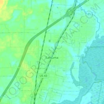
Name: Satsuma topographic map, elevation, terrain.
Location: Satsuma, Mobile County, Alabama, United States (30.83177 -88.09019 30.88045 -88.02717)
Average elevation: 7 m
Minimum elevation: -1 m
Maximum elevation: 21 m
Thank you for supporting this site ❤️
Make a donation
Make a donation
Other topographic maps
Click on a map to view its topography, its elevation and its terrain.