
Thank you for supporting this site ❤️
Make a donation
Make a donation
L'Épinay topographic map
Click on the map to display elevation.
Thank you for supporting this site ❤️
Make a donation
Make a donation
About this map
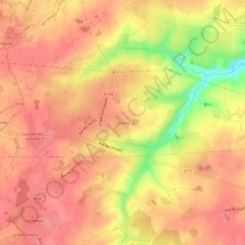
Name: L'Épinay topographic map, elevation, terrain.
Average elevation: 87 m
Minimum elevation: 30 m
Maximum elevation: 108 m
Thank you for supporting this site ❤️
Make a donation
Make a donation
Other topographic maps
Click on a map to view its topography, its elevation and its terrain.
49600
France > Pays de la Loire > Maine-et-Loire > Montrevault-sur-Èvre > La Pétraudière
Average elevation: 83 m
La Boissière-sur-Èvre
France > Pays de la Loire > Maine-et-Loire > Montrevault-sur-Èvre
Average elevation: 79 m
Thank you for supporting this site ❤️
Make a donation
Make a donation
Étang de la Gilière
France > Pays de la Loire > Maine-et-Loire > Montrevault-sur-Èvre
Average elevation: 108 m
Saint-Pierre-Montlimart
France > Pays de la Loire > Maine-et-Loire > Montrevault-sur-Èvre
Average elevation: 77 m
Saint-Rémy-en-Mauges
France > Pays de la Loire > Maine-et-Loire > Montrevault-sur-Èvre
Average elevation: 80 m
Thank you for supporting this site ❤️
Make a donation
Make a donation