
Ikpoba-Okha topographic map
Interactive map
Click on the map to display elevation.
About this map
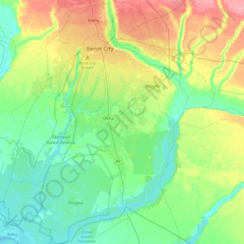
Name: Ikpoba-Okha topographic map, elevation, terrain.
Location: Ikpoba-Okha, Edo State, Nigeria (5.98536 5.44248 6.41855 5.82755)
Average elevation: 45 m
Minimum elevation: 0 m
Maximum elevation: 153 m
Other topographic maps
Click on a map to view its topography, its elevation and its terrain.
Ikpoba River
Nigeria > Edo State > Ikpoba-Okha
Ikpoba River, Ikpoba-Okha, Edo State, Nigeria
Average elevation: 24 m
Benin City
Benin City, Oredo, Edo State, 300241, Nigeria
Average elevation: 72 m